Geolocate

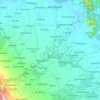
Bato topographic map

Click on the map to display elevation.

About this map

Name: Bato topographic map, elevation, terrain.

Location: Bato, Alangalang, 1st District, Leyte, Eastern Visayas, 6517, Philippines (11.12727 124.82620 11.16727 124.86620)

Average elevation: 58 m

Minimum elevation: 33 m

Maximum elevation: 97 m

Other topographic maps

Click on a map to view its topography, its elevation and its terrain.
Mainit River

Philippines > Leyte > Alangalang

Average elevation: 49 m

Gear up for your next adventure:

🧥Softshell Jacket - Windproof and breathable jacket for hiking
☕Camping Coffee Maker - Brew fresh coffee anywhere on the topographic map
🔪Outdoor Multitool - Versatile tool for repairs and food prep in the wild
🪜Heavy Duty Carabiners - Multi-use clips for securing gear to your backpack
🛶Waterproof Dry Bags - Keep electronics and clothes dry during river crossings

As an Amazon Associate, this site earns from qualifying purchases at no extra cost to you.