Geolocate

Kaylaway topographic map

Click on the map to display elevation.

About this map
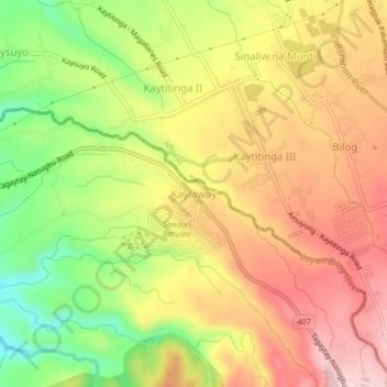
Name: Kaylaway topographic map, elevation, terrain.

Location: Kaylaway, Nasugbu, Batangas, Calabarzon, 4231, Philippines (14.07589 120.80363 14.11589 120.84363)

Average elevation: 431 m

Minimum elevation: 285 m

Maximum elevation: 551 m

Other topographic maps

Click on a map to view its topography, its elevation and its terrain.
Palico River

Philippines > Batangas > Nasugbu > Reparo

Average elevation: 44 m

Batulao

Philippines > Batangas > Nasugbu

Average elevation: 531 m

Talamitam

Philippines > Batangas > Nasugbu > Kayrilaw

Average elevation: 328 m

Pico de Loro Beach

Philippines > Batangas > Nasugbu

Average elevation: 43 m

Fortune Island

Philippines > Batangas > Nasugbu

Average elevation: 1 m

Fortune Island

Philippines > Batangas > Nasugbu

Average elevation: 1 m

Gear up for your next adventure:

🛌Insulated Sleeping Pad - Critical thermal barrier between you and the cold ground
🥾All-Terrain Hiking Boots - Versatile boots for varied hiking conditions
🎒Backpack Rain Cover - External shield to keep your entire pack dry
🧼Biodegradable Camp Soap - Environmentally friendly cleaning for gear and body
🥘Camping Cookware Set - Compact nesting pots and pans for trail cooking

As an Amazon Associate, this site earns from qualifying purchases at no extra cost to you.