
Make a donation
Gear up for your next adventure:
As an Amazon Associate, this site earns from qualifying purchases at no extra cost to you.
Langula topographic map
Click on the map to display elevation.
Make a donation
Gear up for your next adventure:
As an Amazon Associate, this site earns from qualifying purchases at no extra cost to you.
Langula
Die Ortslage von Langula liegt am Westrand des Thüringer Beckens, ca. 7 km von Mühlhausen/Thüringen entfernt und ca. 20 km nordwestlich von Bad Langensalza in einer Höhenlage von etwa 240 m (Kirche). Die Gemarkung schließt im Westen jedoch große Waldgebiete des Hainich mit ein. Mit einer Gipfelhöhe von 468,3 m ü. HN ist der Winterstein am Hainich-Rennstieg daher die höchste Erhebung Langulas. Der Ort befindet sich unweit des Mittelpunktes von Deutschland.
Make a donation
Gear up for your next adventure:
As an Amazon Associate, this site earns from qualifying purchases at no extra cost to you.
About this map
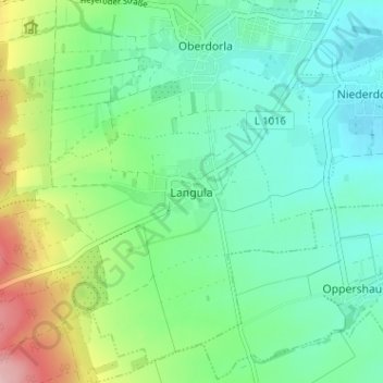
Name: Langula topographic map, elevation, terrain.
Average elevation: 252 m
Minimum elevation: 198 m
Maximum elevation: 391 m
Make a donation
Gear up for your next adventure:
As an Amazon Associate, this site earns from qualifying purchases at no extra cost to you.
Other topographic maps
Click on a map to view its topography, its elevation and its terrain.