
Curado topographic map
Click on the map to display elevation.
About this map
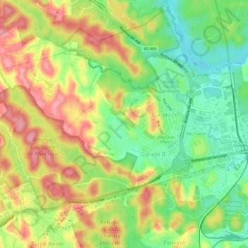
Name: Curado topographic map, elevation, terrain.
Average elevation: 62 m
Minimum elevation: -4 m
Maximum elevation: 129 m
Other topographic maps
Click on a map to view its topography, its elevation and its terrain.
Rio Duas Unas
Brasil > Pernambuco > Região Metropolitana do Recife > Jaboatão dos Guararapes > Vila Marielle Franco
Average elevation: 76 m
Lagoa Azul
Brasil > Pernambuco > Região Metropolitana do Recife > Jaboatão dos Guararapes
Average elevation: 43 m
Rio Jordão
Brasil > Pernambuco > Região Metropolitana do Recife > Jaboatão dos Guararapes
Average elevation: 31 m
Rio das Velhas
Brasil > Pernambuco > Região Metropolitana do Recife > Jaboatão dos Guararapes
Average elevation: 6 m
Rio Jaboatão
Brasil > Pernambuco > Região Metropolitana do Recife > Jaboatão dos Guararapes
Average elevation: 77 m
Portal dos Prazeres
Brasil > Pernambuco > Região Metropolitana do Recife > Jaboatão dos Guararapes > Portal dos Prazeres
Average elevation: 18 m
Praia de Piedade
Brasil > Pernambuco > Região Metropolitana do Recife > Jaboatão dos Guararapes
Average elevation: 5 m
Guruji
Brasil > Pernambuco > Região Metropolitana do Recife > Jaboatão dos Guararapes
Average elevation: 4 m