
Thank you for supporting this site ❤️
Make a donation
Make a donation
Gear up for your next adventure:
As an Amazon Associate, this site earns from qualifying purchases at no extra cost to you.
Burgui/Burgi topographic map
Click on the map to display elevation.
Thank you for supporting this site ❤️
Make a donation
Make a donation
Gear up for your next adventure:
As an Amazon Associate, this site earns from qualifying purchases at no extra cost to you.
About this map
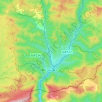
Name: Burgui/Burgi topographic map, elevation, terrain.
Location: Burgui/Burgi, Pirinioak / Pirineo, Navarre, 31412, Spain (42.69916 -1.05229 42.77672 -0.92334)
Average elevation: 878 m
Minimum elevation: 581 m
Maximum elevation: 1,408 m
Thank you for supporting this site ❤️
Make a donation
Make a donation
Gear up for your next adventure:
As an Amazon Associate, this site earns from qualifying purchases at no extra cost to you.
Other topographic maps
Click on a map to view its topography, its elevation and its terrain.