
Make a donation
Gear up for your next adventure:
As an Amazon Associate, this site earns from qualifying purchases at no extra cost to you.
Handthal topographic map
Click on the map to display elevation.
Make a donation
Gear up for your next adventure:
As an Amazon Associate, this site earns from qualifying purchases at no extra cost to you.
Handthal
Den Mittelpunkt der Siedlung bildet die katholische Filialkirche St. Maria Magdalena. Ursprünglich stand sie auf der Höhe des Madgalenenberges und war das Ziel vieler Pilger. Sie wurde 1729 geweiht. Im Jahr 1810 wurde den Handthalern der Wiederaufbau der aufgelösten Hospizkirche genehmigt und die Magdalenenkirche entstand im Dorf neu. Oberhalb des Chores befindet sich ein sechsseitiger Dachreiter.
Make a donation
Gear up for your next adventure:
As an Amazon Associate, this site earns from qualifying purchases at no extra cost to you.
About this map
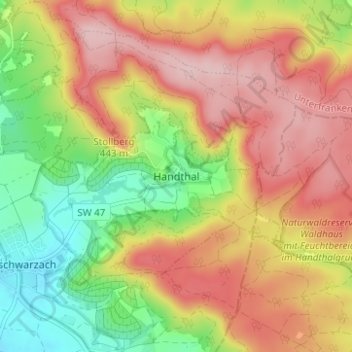
Name: Handthal topographic map, elevation, terrain.
Average elevation: 380 m
Minimum elevation: 272 m
Maximum elevation: 478 m
Make a donation
Gear up for your next adventure:
As an Amazon Associate, this site earns from qualifying purchases at no extra cost to you.