
Thank you for supporting this site ❤️
Make a donation
Make a donation
Gear up for your next adventure:
As an Amazon Associate, this site earns from qualifying purchases at no extra cost to you.
Argelia topographic map
Click on the map to display elevation.
Thank you for supporting this site ❤️
Make a donation
Make a donation
Gear up for your next adventure:
As an Amazon Associate, this site earns from qualifying purchases at no extra cost to you.
About this map
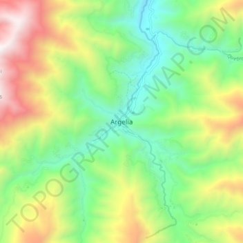
Name: Argelia topographic map, elevation, terrain.
Location: Argelia, Sur del Cauca, Cauca, RAP Pacífico, Colombia (2.21681 -77.28941 2.29681 -77.20941)
Average elevation: 1,758 m
Minimum elevation: 1,070 m
Maximum elevation: 2,912 m
Thank you for supporting this site ❤️
Make a donation
Make a donation
Gear up for your next adventure:
As an Amazon Associate, this site earns from qualifying purchases at no extra cost to you.