
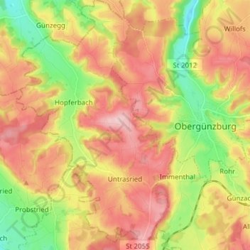
Untrasried topographic map
Interactive map
Click on the map to display elevation.
About this map
Name: Untrasried topographic map, elevation, terrain.
Average elevation: 807 m
Minimum elevation: 699 m
Maximum elevation: 905 m
Untrasried liegt in der Region Allgäu im Günztal und ist die am westlichsten gelegene Gemeinde des Landkreises Ostallgäu. Am südlichen Ortsrand entspringt die Westliche Günz. Nach etwa neunzehn Kilometern vereinigt sie sich bei Lauben (Landkreis Unterallgäu) mit der Östlichen Günz zur Günz, die bei Günzburg in die Donau mündet. Die Gemeinde liegt zwischen 725 m ü. NHN (westliche Günz) und 902 m ü. NHN (Eschers Höhe) hoch.
Other topographic maps
Click on a map to view its topography, its elevation and its terrain.
Höhen
Deutschland > Bayern > Landkreis Ostallgäu > Rückholz
Höhen, Rückholz, Seeg (VGem), Landkreis Ostallgäu, Bayern, 87494, Deutschland
Average elevation: 879 m