
Make a donation
Gear up for your next adventure:
As an Amazon Associate, this site earns from qualifying purchases at no extra cost to you.
Oficina Cota topographic map
Click on the map to display elevation.
Make a donation
Gear up for your next adventure:
As an Amazon Associate, this site earns from qualifying purchases at no extra cost to you.
About this map
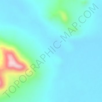
Name: Oficina Cota topographic map, elevation, terrain.
Average elevation: 1,012 m
Minimum elevation: 957 m
Maximum elevation: 1,271 m
Make a donation
Gear up for your next adventure:
As an Amazon Associate, this site earns from qualifying purchases at no extra cost to you.
Other topographic maps
Click on a map to view its topography, its elevation and its terrain.
Observatorio Paranal
Chile > Región de Antofagasta > Provincia de Antofagasta > Antofagasta
Average elevation: 2,361 m
La Rinconada
Chile > Región de Antofagasta > Provincia de Antofagasta > Antofagasta > La Rinconada
Average elevation: 35 m
Monumento Natural Paposo Norte
Chile > Región de Antofagasta > Provincia de Antofagasta > Antofagasta
Average elevation: 631 m