
Make a donation
Gear up for your next adventure:
As an Amazon Associate, this site earns from qualifying purchases at no extra cost to you.
Metello topographic map
Click on the map to display elevation.
Make a donation
Gear up for your next adventure:
As an Amazon Associate, this site earns from qualifying purchases at no extra cost to you.
About this map
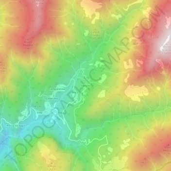
Name: Metello topographic map, elevation, terrain.
Average elevation: 1,186 m
Minimum elevation: 696 m
Maximum elevation: 1,732 m
Make a donation
Gear up for your next adventure:
As an Amazon Associate, this site earns from qualifying purchases at no extra cost to you.
Other topographic maps
Click on a map to view its topography, its elevation and its terrain.
Barga
Die Altstadt Bargas liegt auf einer Anhöhe, die vom romanischen Dom gekrönt wird. Neben dem Dom befindet sich der Palazzo Pretorio. Er wurde im 14. Jahrhundert erbaut und war der Amtssitz des florentinischen Verwalters der Stadt, heute befindet sich dort das Städtische Museum.
Average elevation: 624 m
Make a donation
Gear up for your next adventure:
As an Amazon Associate, this site earns from qualifying purchases at no extra cost to you.
Make a donation
Gear up for your next adventure:
As an Amazon Associate, this site earns from qualifying purchases at no extra cost to you.