
Make a donation
Gear up for your next adventure:
As an Amazon Associate, this site earns from qualifying purchases at no extra cost to you.
Douradina topographic map
Click on the map to display elevation.
Make a donation
Gear up for your next adventure:
As an Amazon Associate, this site earns from qualifying purchases at no extra cost to you.
Douradina
O Município de Douradina está localizado na região Noroeste do Estado do Paraná, possuindo uma latitude 23º22'51" sul e a uma longitude 53º17'30" oeste. Sua altitude é de 406 metros, a área total de 420,23 km² e a população, conforme estimativas do IBGE de 2018, era de 8 621 habitantes.
Make a donation
Gear up for your next adventure:
As an Amazon Associate, this site earns from qualifying purchases at no extra cost to you.
About this map
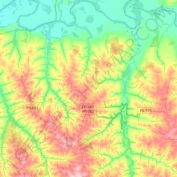
Name: Douradina topographic map, elevation, terrain.
Average elevation: 316 m
Minimum elevation: 230 m
Maximum elevation: 456 m
Make a donation
Gear up for your next adventure:
As an Amazon Associate, this site earns from qualifying purchases at no extra cost to you.
Other topographic maps
Click on a map to view its topography, its elevation and its terrain.
Reserva Biológica das Perobas
Brasil > Paraná > Região Metropolitana de Umuarama > Cianorte
Average elevation: 508 m
Make a donation
Gear up for your next adventure:
As an Amazon Associate, this site earns from qualifying purchases at no extra cost to you.
Caramuru
Brasil > Paraná > Região Metropolitana de Umuarama > São Jorge do Patrocínio
Average elevation: 298 m
Serra dos Dourados
Brasil > Paraná > Região Metropolitana de Umuarama > Umuarama
Average elevation: 426 m
Make a donation
Gear up for your next adventure:
As an Amazon Associate, this site earns from qualifying purchases at no extra cost to you.
Make a donation
Gear up for your next adventure:
As an Amazon Associate, this site earns from qualifying purchases at no extra cost to you.