Geolocate

Arani topographic map

Click on the map to display elevation.

Arani

Arni is located at 12°40′N 79°17′E / 12.67°N 79.28°E / 12.67; 79.28 on the banks of the Kamandala Naaga river. It has an average elevation of 151 metres (495 ft).

Wikipedia (CC-BY-SA 3.0)

About this map

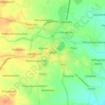
Name: Arani topographic map, elevation, terrain.

Location: Arani, Tiruvannamalai District, Tamil Nadu, 632300, India (12.62770 79.24528 12.70770 79.32528)

Average elevation: 143 m

Minimum elevation: 125 m

Maximum elevation: 164 m

Gear up for your next adventure:

🧥Waterproof Jacket - Lightweight rain jackets for hiking and outdoor activities
🧥Ultralight Puffy Jacket - Maximum warmth that packs down to the size of an orange
🥾Durable Hiking Shoes - Long-lasting shoes for frequent hiking
💧Reusable Water Bottle - Durable water bottles for hydration on trails
🥾Hiking Boots - Sturdy boots providing ankle support and traction on rugged trails

As an Amazon Associate, this site earns from qualifying purchases at no extra cost to you.