
Make a donation
Gear up for your next adventure:
As an Amazon Associate, this site earns from qualifying purchases at no extra cost to you.
Tarzo topographic map
Click on the map to display elevation.
Make a donation
Gear up for your next adventure:
As an Amazon Associate, this site earns from qualifying purchases at no extra cost to you.
About this map
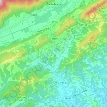
Name: Tarzo topographic map, elevation, terrain.
Location: Tarzo, Treviso, Venetien, 31020, Italien (45.93760 12.17915 45.99335 12.26177)
Average elevation: 270 m
Minimum elevation: 100 m
Maximum elevation: 794 m
Make a donation
Gear up for your next adventure:
As an Amazon Associate, this site earns from qualifying purchases at no extra cost to you.
Other topographic maps
Click on a map to view its topography, its elevation and its terrain.
Monte Grappa
Die SP148 verbindet Caupo im Norden mit Romano d’Ezzelino im Süden und weist eine maximale Höhe von rund 1600 Metern auf. Sie verläuft westlich des Gipfels. Die Nordauffahrt ist 29,6 Kilometer lang und steigt durchschnittlich 4,8 % an, wobei sich speziell in der zweiten Hälfte kurze Abfahrten mit steilen…
Average elevation: 1,502 m
Make a donation
Gear up for your next adventure:
As an Amazon Associate, this site earns from qualifying purchases at no extra cost to you.