
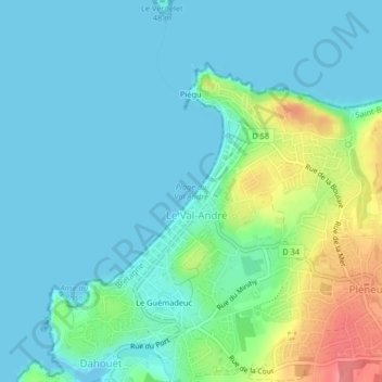
Plage du Val André topographic map
Interactive map
Click on the map to display elevation.
About this map
Name: Plage du Val André topographic map, elevation, terrain.
Average elevation: 17 m
Minimum elevation: -1 m
Maximum elevation: 77 m
Other topographic maps
Click on a map to view its topography, its elevation and its terrain.
Port de Dahouët
France > Bretagne > Pléneuf-Val-André
Port de Dahouët, Pléneuf-Val-André, Saint-Brieuc, Côtes-d'Armor, Bretagne, France métropolitaine, 22370, France
Average elevation: 23 m
Anse du Pissot
France > Bretagne > Pléneuf-Val-André
Anse du Pissot, Rue Aristide Baudry, La Caderie, Pléneuf-Val-André, Saint-Brieuc, Côtes-d'Armor, Bretagne, France métropolitaine, 22370, France
Average elevation: 12 m