
Santomera topographic map
Interactive map
Click on the map to display elevation.
About this map
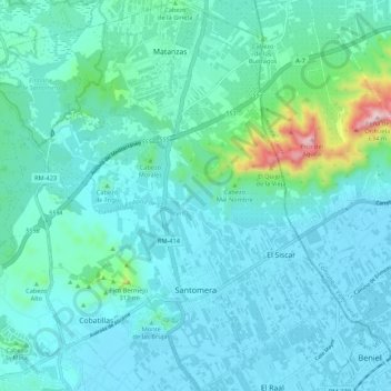
Name: Santomera topographic map, elevation, terrain.
Location: Santomera, Verger-de-Murcie, Région de Murcie, 30140, Espagne (38.03978 -1.10525 38.12413 -1.01042)
Average elevation: 104 m
Minimum elevation: 24 m
Maximum elevation: 618 m
Other topographic maps
Click on a map to view its topography, its elevation and its terrain.
Murcie
Espagne > Région de Murcie > Verger-de-Murcie
Murcie, Verger-de-Murcie, Région de Murcie, Espagne
Average elevation: 171 m