
Make a donation
Gear up for your next adventure:
As an Amazon Associate, this site earns from qualifying purchases at no extra cost to you.
Moricone topographic map
Click on the map to display elevation.
Make a donation
Gear up for your next adventure:
As an Amazon Associate, this site earns from qualifying purchases at no extra cost to you.
About this map
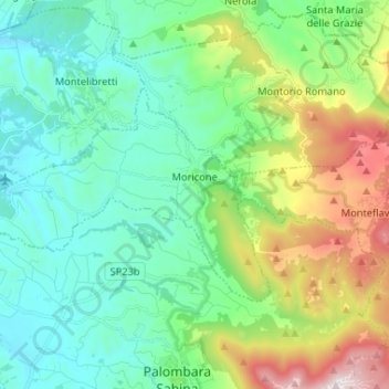
Name: Moricone topographic map, elevation, terrain.
Location: Moricone, Roma Capitale, Lazio, Italië (42.08603 12.66660 42.13924 12.79698)
Average elevation: 360 m
Minimum elevation: 68 m
Maximum elevation: 1,170 m
Make a donation
Gear up for your next adventure:
As an Amazon Associate, this site earns from qualifying purchases at no extra cost to you.
Other topographic maps
Click on a map to view its topography, its elevation and its terrain.
Make a donation
Gear up for your next adventure:
As an Amazon Associate, this site earns from qualifying purchases at no extra cost to you.
Lago di Traiano
Italië > Lazio > Roma Capitale > Fiumicino > Episcopio di Porto
Average elevation: 3 m