
Make a donation
Gear up for your next adventure:
As an Amazon Associate, this site earns from qualifying purchases at no extra cost to you.
Shirleysburg topographic map
Click on the map to display elevation.
Make a donation
Gear up for your next adventure:
As an Amazon Associate, this site earns from qualifying purchases at no extra cost to you.
About this map
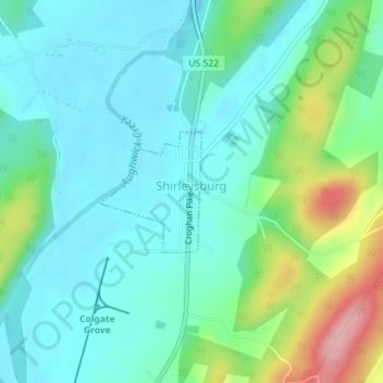
Name: Shirleysburg topographic map, elevation, terrain.
Location: Shirleysburg, Huntingdon County, Pennsylvania, United States (40.29314 -77.88267 40.30169 -77.87320)
Average elevation: 209 m
Minimum elevation: 166 m
Maximum elevation: 341 m
Make a donation
Gear up for your next adventure:
As an Amazon Associate, this site earns from qualifying purchases at no extra cost to you.
Other topographic maps
Click on a map to view its topography, its elevation and its terrain.
Warriors Mark
United States > Pennsylvania > Huntingdon County > Warriors Mark Township
Average elevation: 370 m
Make a donation
Gear up for your next adventure:
As an Amazon Associate, this site earns from qualifying purchases at no extra cost to you.
Spruce Creek
United States > Pennsylvania > Huntingdon County > Spruce Creek Township
Average elevation: 329 m
Puttstown
United States > Pennsylvania > Huntingdon County > Hopewell Township
Average elevation: 330 m
Make a donation
Gear up for your next adventure:
As an Amazon Associate, this site earns from qualifying purchases at no extra cost to you.
Pennsylvania Furnace
United States > Pennsylvania > Huntingdon County > Franklin Township
Average elevation: 363 m
McAlevys Fort
United States > Pennsylvania > Huntingdon County > Jackson Township
Average elevation: 265 m
Make a donation
Gear up for your next adventure:
As an Amazon Associate, this site earns from qualifying purchases at no extra cost to you.
McConnellstown
United States > Pennsylvania > Huntingdon County > Walker Township
Average elevation: 257 m
Make a donation
Gear up for your next adventure:
As an Amazon Associate, this site earns from qualifying purchases at no extra cost to you.
Blairs Mills
United States > Pennsylvania > Huntingdon County > Tell Township
Average elevation: 283 m
Lake Jeanette
United States > Pennsylvania > Huntingdon County > Jackson Township
Average elevation: 268 m
Water Street
United States > Pennsylvania > Huntingdon County > Morris Township
Average elevation: 319 m
Make a donation
Gear up for your next adventure:
As an Amazon Associate, this site earns from qualifying purchases at no extra cost to you.