
Make a donation
Gear up for your next adventure:
As an Amazon Associate, this site earns from qualifying purchases at no extra cost to you.
Patzún topographic map
Click on the map to display elevation.
Make a donation
Gear up for your next adventure:
As an Amazon Associate, this site earns from qualifying purchases at no extra cost to you.
About this map
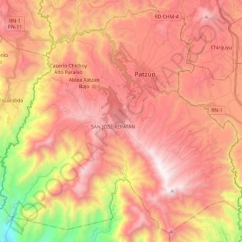
Name: Patzún topographic map, elevation, terrain.
Location: Patzún, Chimaltenango, Guatemala (14.57621 -91.11174 14.72375 -90.94680)
Average elevation: 2,054 m
Minimum elevation: 936 m
Maximum elevation: 2,753 m
Make a donation
Gear up for your next adventure:
As an Amazon Associate, this site earns from qualifying purchases at no extra cost to you.
Other topographic maps
Click on a map to view its topography, its elevation and its terrain.
Bosque San Antionio
Guatemala > Chimaltenango > San Juan Comalapa > San Juan Comalapa
Average elevation: 2,125 m
Make a donation
Gear up for your next adventure:
As an Amazon Associate, this site earns from qualifying purchases at no extra cost to you.
Bosque San Antionio
Guatemala > Chimaltenango > San Juan Comalapa > San Juan Comalapa
Average elevation: 2,125 m