
Noyant topographic map
Click on the map to display elevation.
Noyant
L'altitude de la commune varie de 51 à 89 mètres, pour une altitude moyenne de 70 mètres.
About this map
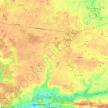
Name: Noyant topographic map, elevation, terrain.
Average elevation: 81 m
Minimum elevation: 48 m
Maximum elevation: 97 m
Other topographic maps
Click on a map to view its topography, its elevation and its terrain.
Barrage des Mousseaux
France > Pays de la Loire > Maine-et-Loire > Noyant-Villages
Average elevation: 80 m
Manoir de Breil de Foin
France > Pays de la Loire > Maine-et-Loire > Noyant-Villages
Average elevation: 78 m