Geolocate

Stratford topographic map

Click on the map to display elevation.

About this map

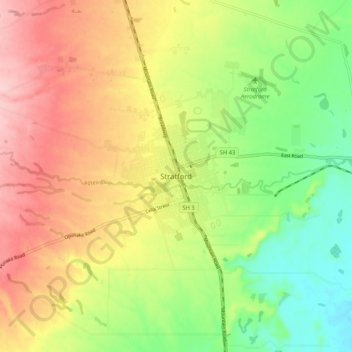
Name: Stratford topographic map, elevation, terrain.

Location: Stratford, Stratford District, Taranaki, 4332, New Zealand (-39.37969 174.24409 -39.29969 174.32409)

Average elevation: 310 m

Minimum elevation: 220 m

Maximum elevation: 410 m

Gear up for your next adventure:

🧶550 Survival Paracord - Versatile utility cord for emergency repairs and rigging
👟Leg Gaiters - Keep debris, mud, and snow out of your boots
🧢Sun Hat - Wide-brim hat for sun protection
🧭GPS Outdoor Watch - Smart watch for navigation and fitness tracking in nature
🔋Solar Power Bank - Keep your GPS and devices charged during long outdoor trips

As an Amazon Associate, this site earns from qualifying purchases at no extra cost to you.