Geolocate

South Varanki topographic map

Click on the map to display elevation.

About this map

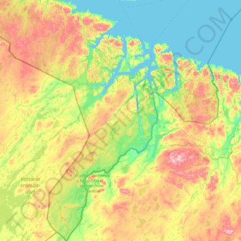
Name: South Varanki topographic map, elevation, terrain.

Location: South Varanki, Troms og Finnmark, Norway (69.01083 28.33048 70.06426 31.19832)

Average elevation: 150 m

Minimum elevation: -5 m

Maximum elevation: 625 m

Other topographic maps

Click on a map to view its topography, its elevation and its terrain.

Nord-Lenangen

Norway > Troms og Finnmark

Average elevation: 52 m

Lyngseidet

Norway > Troms og Finnmark

Average elevation: 181 m

Stordalen

Norway > Troms og Finnmark > Tromsø > Stordalen

Average elevation: 150 m

Gear up for your next adventure:

🧊Portable Cooler - Keep food and drinks cold during outdoor adventures
🚲Bike Repair Kit - Essential tools for on-trail mechanical issues
🧢Sun Protection Cap - Breathable cap to protect from sun exposure
🪑Insulated Seat Pad - Protect your seat from cold rocks and wet logs
🧤Insulated Winter Gloves - Heavy-duty protection for sub-zero Canadian adventures

As an Amazon Associate, this site earns from qualifying purchases at no extra cost to you.