Geolocate

Tea Tree topographic map

Click on the map to display elevation.

About this map

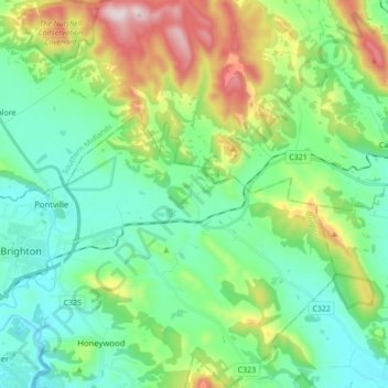
Name: Tea Tree topographic map, elevation, terrain.

Location: Tea Tree, Hobart, Brighton, Tasmania, 7017, Australia (-42.74454 147.28870 -42.61714 147.39315)

Average elevation: 182 m

Minimum elevation: 1 m

Maximum elevation: 657 m

Other topographic maps

Click on a map to view its topography, its elevation and its terrain.

Snug Falls

Australia > Tasmania > Hobart > Snug

Average elevation: 336 m

Knocklofty

Australia > Tasmania > Hobart

Average elevation: 185 m

Mount Direction

Australia > Tasmania > Hobart

Average elevation: 166 m

Glebe Hill

Australia > Tasmania > Hobart

Average elevation: 66 m

Selfs Point

Australia > Tasmania > Hobart

Average elevation: 17 m

Waterworks Reserve

Australia > Tasmania > Hobart

Average elevation: 240 m

James Austin Park

Australia > Tasmania > Hobart

Average elevation: 25 m

Perrins Ridge

Australia > Tasmania > Hobart

Average elevation: 467 m

Cartwright Point

Australia > Tasmania > Hobart

Average elevation: 59 m

Tolosa Park

Australia > Tasmania > Hobart

Average elevation: 182 m

Glenrose Park

Australia > Tasmania > Hobart

Average elevation: 181 m

Gear up for your next adventure:

🩹Compact First Aid Kit - Pre-packed essentials for common trail injuries
🎒Hiking Backpack - Lightweight and ergonomic backpacks for day hikes or multi-day treks
🥾Waterproof Hiking Boots - Essential footwear for rugged terrain and wet Canadian trails
🧥Softshell Hiking Jacket - The perfect balance of wind protection and breathability
🧭GPS Tracker - Track your location in remote areas safely

As an Amazon Associate, this site earns from qualifying purchases at no extra cost to you.