
Make a donation
Gear up for your next adventure:
As an Amazon Associate, this site earns from qualifying purchases at no extra cost to you.
Pian del Falco topographic map
Click on the map to display elevation.
Make a donation
Gear up for your next adventure:
As an Amazon Associate, this site earns from qualifying purchases at no extra cost to you.
About this map
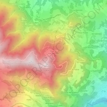
Name: Pian del Falco topographic map, elevation, terrain.
Average elevation: 1,043 m
Minimum elevation: 551 m
Maximum elevation: 1,528 m
Make a donation
Gear up for your next adventure:
As an Amazon Associate, this site earns from qualifying purchases at no extra cost to you.
Other topographic maps
Click on a map to view its topography, its elevation and its terrain.
Lago della Ninfa
Italia > Emilia-Romagna > Modena > Sestola
Il lago della Ninfa è un lago originatosi lungo un ampio movimento franoso, oggi mantenuto artificialmente, posto a 1.500 metri di altitudine, alle pendici del monte Cimone, nel comune di Sestola.
Average elevation: 1,476 m