
Make a donation
Gear up for your next adventure:
As an Amazon Associate, this site earns from qualifying purchases at no extra cost to you.
Weston Hill topographic map
Click on the map to display elevation.
Make a donation
Gear up for your next adventure:
As an Amazon Associate, this site earns from qualifying purchases at no extra cost to you.
About this map
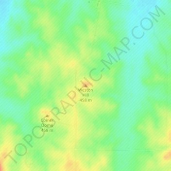
Name: Weston Hill topographic map, elevation, terrain.
Location: Weston Hill, Saline County, Kansas, United States (38.69246 -97.84954 38.69256 -97.84944)
Average elevation: 437 m
Minimum elevation: 418 m
Maximum elevation: 461 m
Make a donation
Gear up for your next adventure:
As an Amazon Associate, this site earns from qualifying purchases at no extra cost to you.
Other topographic maps
Click on a map to view its topography, its elevation and its terrain.
Salina
United States > Kansas > Saline County
Salina is located at 38°50′25″N 97°36′41″W / 38.84028°N 97.61139°W / 38.84028; -97.61139 (38.8402805, -97.6114237) at an elevation of 1,224 feet (373 m). Located in North Central Kansas at the intersection of Interstate 70 and Interstate 135, it is 81 miles (130 km) north of Wichita,…
Average elevation: 383 m
Make a donation
Gear up for your next adventure:
As an Amazon Associate, this site earns from qualifying purchases at no extra cost to you.