Geolocate

Ratzeburg topographic map

Click on the map to display elevation.

About this map

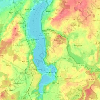
Name: Ratzeburg topographic map, elevation, terrain.

Location: Ratzeburg, Herzogtum Lauenburg, Schleswig-Holstein, Germany (53.67029 10.72670 53.78144 10.82688)

Average elevation: 39 m

Minimum elevation: -1 m

Maximum elevation: 88 m

Gear up for your next adventure:

👟Trail Running Shoes - Agile footwear for fast-paced topographic exploration
Lightweight Camping Tent - Portable shelter optimized for Canadian backcountry camping
🧴Waterproofing Spray - Restore the DWR coating on jackets and tents
🥾Mountain Hiking Boots - High-traction boots for rocky terrain
🧥Ultralight Puffy Jacket - Maximum warmth that packs down to the size of an orange

As an Amazon Associate, this site earns from qualifying purchases at no extra cost to you.