
Make a donation
Gear up for your next adventure:
As an Amazon Associate, this site earns from qualifying purchases at no extra cost to you.
Kastellaun topographic map
Click on the map to display elevation.
Make a donation
Gear up for your next adventure:
As an Amazon Associate, this site earns from qualifying purchases at no extra cost to you.
Kastellaun
Die Anbindung an den überörtlichen Verkehr ist über die seit 2014 fertiggestellte Umgehungsstraße B 327 (Hunsrückhöhenstraße) gegeben. Der Flughafen Frankfurt-Hahn befindet sich ca. 20 km in südlicher Richtung von Kastellaun und ist über die Hunsrückhöhenstraße erreichbar.
Make a donation
Gear up for your next adventure:
As an Amazon Associate, this site earns from qualifying purchases at no extra cost to you.
About this map
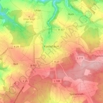
Name: Kastellaun topographic map, elevation, terrain.
Average elevation: 436 m
Minimum elevation: 332 m
Maximum elevation: 503 m
Make a donation
Gear up for your next adventure:
As an Amazon Associate, this site earns from qualifying purchases at no extra cost to you.