
Make a donation
Gear up for your next adventure:
As an Amazon Associate, this site earns from qualifying purchases at no extra cost to you.
Kinnelon topographic map
Click on the map to display elevation.
Make a donation
Gear up for your next adventure:
As an Amazon Associate, this site earns from qualifying purchases at no extra cost to you.
Kinnelon
The highest mountain in Kinnelon is Kitty Ann Mountain. Located in Smoke Rise, the mountain offers views of northern New Jersey at an elevation of 1,140 feet (350 m) from the Smoke Rise Tower.
Make a donation
Gear up for your next adventure:
As an Amazon Associate, this site earns from qualifying purchases at no extra cost to you.
About this map
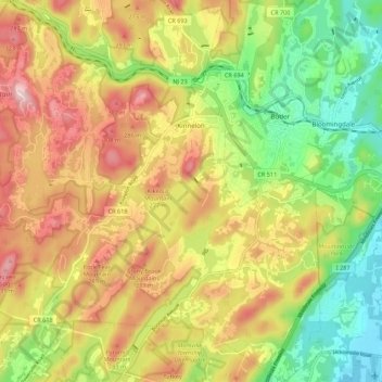
Name: Kinnelon topographic map, elevation, terrain.
Location: Kinnelon, Morris County, New Jersey, 07405, United States (40.94630 -74.43364 41.02876 -74.32979)
Average elevation: 196 m
Minimum elevation: 54 m
Maximum elevation: 351 m
Make a donation
Gear up for your next adventure:
As an Amazon Associate, this site earns from qualifying purchases at no extra cost to you.
Other topographic maps
Click on a map to view its topography, its elevation and its terrain.
Make a donation
Gear up for your next adventure:
As an Amazon Associate, this site earns from qualifying purchases at no extra cost to you.
Powder Mill Pond Dam
United States > New Jersey > Morris County > Parsippany-Troy Hills > Tabor
Average elevation: 178 m
Make a donation
Gear up for your next adventure:
As an Amazon Associate, this site earns from qualifying purchases at no extra cost to you.
Washington Valley
United States > New Jersey > Morris County > Morris Township
Average elevation: 152 m
Lake Parsippany
United States > New Jersey > Morris County > Parsippany-Troy Hills
Average elevation: 93 m
Pleasant Valley
United States > New Jersey > Morris County > Mendham Township
Average elevation: 156 m
Make a donation
Gear up for your next adventure:
As an Amazon Associate, this site earns from qualifying purchases at no extra cost to you.
Schooleys Mountain
United States > New Jersey > Morris County > Washington Township
Average elevation: 293 m
Washington Corner
United States > New Jersey > Morris County > Mendham Township
Average elevation: 174 m
Make a donation
Gear up for your next adventure:
As an Amazon Associate, this site earns from qualifying purchases at no extra cost to you.
Make a donation
Gear up for your next adventure:
As an Amazon Associate, this site earns from qualifying purchases at no extra cost to you.
Calais Crossroads
United States > New Jersey > Morris County > Randolph Township
Average elevation: 284 m
Make a donation
Gear up for your next adventure:
As an Amazon Associate, this site earns from qualifying purchases at no extra cost to you.
Make a donation
Gear up for your next adventure:
As an Amazon Associate, this site earns from qualifying purchases at no extra cost to you.
Make a donation
Gear up for your next adventure:
As an Amazon Associate, this site earns from qualifying purchases at no extra cost to you.
Mooney Mountain Park
United States > New Jersey > Morris County > Roxbury Township
Average elevation: 326 m
Lake Hiawatha
United States > New Jersey > Morris County > Parsippany-Troy Hills
Average elevation: 76 m
Lower Montville
United States > New Jersey > Morris County > Montville Township
Average elevation: 84 m
Make a donation
Gear up for your next adventure:
As an Amazon Associate, this site earns from qualifying purchases at no extra cost to you.
Beach Glen
United States > New Jersey > Morris County > Rockaway Township > Beach Glen
Average elevation: 209 m
Make a donation
Gear up for your next adventure:
As an Amazon Associate, this site earns from qualifying purchases at no extra cost to you.
Floral Hill
United States > New Jersey > Morris County > Chatham Township > Floral Hill
Average elevation: 90 m
Rockaway Valley
United States > New Jersey > Morris County > Boonton Township
Average elevation: 181 m
Make a donation
Gear up for your next adventure:
As an Amazon Associate, this site earns from qualifying purchases at no extra cost to you.
Roxbury Township
United States > New Jersey > Morris County > Roxbury Township
Average elevation: 264 m