
Thank you for supporting this site ❤️
Make a donation
Make a donation
Gear up for your next adventure:
As an Amazon Associate, this site earns from qualifying purchases at no extra cost to you.
Nainggolan topographic map
Click on the map to display elevation.
Thank you for supporting this site ❤️
Make a donation
Make a donation
Gear up for your next adventure:
As an Amazon Associate, this site earns from qualifying purchases at no extra cost to you.
About this map
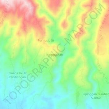
Name: Nainggolan topographic map, elevation, terrain.
Location: Nainggolan, Samosir, North Sumatra, Sumatra, Indonesia (2.44211 98.87720 2.48211 98.91720)
Average elevation: 1,069 m
Minimum elevation: 910 m
Maximum elevation: 1,302 m
Thank you for supporting this site ❤️
Make a donation
Make a donation
Gear up for your next adventure:
As an Amazon Associate, this site earns from qualifying purchases at no extra cost to you.
Other topographic maps
Click on a map to view its topography, its elevation and its terrain.
Kelurahan parhusip III Kecamatan Nainggolan
Indonesia > North Sumatra > Samosir
Average elevation: 914 m