Geolocate

Haurwangi topographic map

Click on the map to display elevation.

About this map

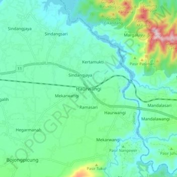
Name: Haurwangi topographic map, elevation, terrain.

Location: Haurwangi, Cianjur, West Java, Java, 63282, Indonesia (-6.85894 107.26008 -6.77894 107.34008)

Average elevation: 286 m

Minimum elevation: 207 m

Maximum elevation: 561 m

Other topographic maps

Click on a map to view its topography, its elevation and its terrain.

Cidaun

Indonesia > West Java > Cianjur

Average elevation: 658 m

Kertajadi

Indonesia > West Java > Cianjur

Average elevation: 108 m

Agrabinta

Indonesia > West Java > Cianjur

Average elevation: 108 m

Karangwangi

Indonesia > West Java > Cianjur

Average elevation: 119 m

Wanasari

Indonesia > West Java > Cianjur

Average elevation: 31 m

Cisalak

Indonesia > West Java > Cianjur

Average elevation: 49 m

Jayapura

Indonesia > West Java > Cianjur

Average elevation: 73 m

Gear up for your next adventure:

🧰Multitool Knife - Compact and versatile tool for outdoor use
🥾Light Hiking Boots - Lightweight and comfortable boots for day hikes
🧊Insulated Water Bottle - Keeps drinks cold in summer and prevents freezing in winter
🧭GPS Handheld Device - Reliable GPS navigation for outdoor adventures
🧭Orienteering Kit - Tools for map reading and navigation in the wild

As an Amazon Associate, this site earns from qualifying purchases at no extra cost to you.