
Cihideung topographic map
Click on the map to display elevation.
About this map
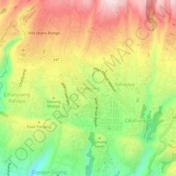
Name: Cihideung topographic map, elevation, terrain.
Location: Cihideung, West Bandung, West Java, Java, 40391, Indonesia (-6.83042 107.57287 -6.79042 107.61287)
Average elevation: 1,259 m
Minimum elevation: 1,030 m
Maximum elevation: 1,480 m
Other topographic maps
Click on a map to view its topography, its elevation and its terrain.
Ir. H. Juanda Grand Forest Park
Indonesia > West Java > West Bandung > Langensari
Average elevation: 1,101 m
DUSUN PALASARI DESA CINTA ASIH KC. CIPONGKOR KAB. BANDUNG BARAT
Indonesia > West Java > West Bandung
Average elevation: 1,013 m
Outbond Ciwangun Indah Camp
Indonesia > West Java > West Bandung > Kertawangi
Average elevation: 1,447 m