
Make a donation
Gear up for your next adventure:
As an Amazon Associate, this site earns from qualifying purchases at no extra cost to you.
Oberhundem topographic map
Click on the map to display elevation.
Make a donation
Gear up for your next adventure:
As an Amazon Associate, this site earns from qualifying purchases at no extra cost to you.
Oberhundem
Oberhundem liegt westlich vom Hauptkamm (Rothaarkamm) des Rothaargebirges etwa 6 km östlich des Kernorts von Kirchhundem in einem Talkessel auf etwa 412 m ü. NN. Im Naturpark Sauerland-Rothaargebirge befindet es sich direkt nordöstlich der Einmündung der Wigge (Wiggesiepen) in den Oberlauf der durch das Dorf fließenden Hundem. Während in den unbebauten Tallagen Grünlandwirtschaft betrieben wird, sind die Höhenlagen durchgehend von Weihnachtsbaumkulturen und Fichtenhochwald bedeckt.
Make a donation
Gear up for your next adventure:
As an Amazon Associate, this site earns from qualifying purchases at no extra cost to you.
About this map
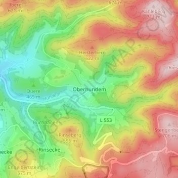
Name: Oberhundem topographic map, elevation, terrain.
Average elevation: 524 m
Minimum elevation: 352 m
Maximum elevation: 713 m
Make a donation
Gear up for your next adventure:
As an Amazon Associate, this site earns from qualifying purchases at no extra cost to you.
Other topographic maps
Click on a map to view its topography, its elevation and its terrain.