
Make a donation
Gear up for your next adventure:
As an Amazon Associate, this site earns from qualifying purchases at no extra cost to you.
Chorvoq topographic map
Click on the map to display elevation.
Make a donation
Gear up for your next adventure:
As an Amazon Associate, this site earns from qualifying purchases at no extra cost to you.
About this map
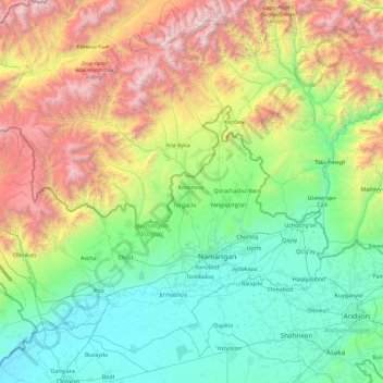
Name: Chorvoq topographic map, elevation, terrain.
Location: Chorvoq, Namangan Region, 160300, Uzbekistan (40.53273 70.84919 41.93273 72.24919)
Average elevation: 1,370 m
Minimum elevation: 357 m
Maximum elevation: 4,398 m
Make a donation
Gear up for your next adventure:
As an Amazon Associate, this site earns from qualifying purchases at no extra cost to you.
Other topographic maps
Click on a map to view its topography, its elevation and its terrain.
Tashkent
Tashkent features a Mediterranean climate (Köppen: Csa) bordering a humid continental climate (Köppen: Dsa). As a result, Tashkent experiences cold and often snowy winters not typically associated with most Mediterranean climates and long, hot and dry summers. Most precipitation occurs during winter, which…
Average elevation: 441 m
Make a donation
Gear up for your next adventure:
As an Amazon Associate, this site earns from qualifying purchases at no extra cost to you.
Make a donation
Gear up for your next adventure:
As an Amazon Associate, this site earns from qualifying purchases at no extra cost to you.
Tashkent
Tashkent features a Mediterranean climate (Köppen: Csa) with some humid continental climate influences (Köppen: Dsa). As a result, Tashkent experiences cold and often snowy winters not typically associated with most Mediterranean climates and long, hot and dry summers. Most precipitation occurs during the…
Average elevation: 441 m
Tashkent
Tashkent features a Mediterranean climate (Köppen: Csa) bordering a humid continental climate (Köppen: Dsa). As a result, Tashkent experiences cold and often snowy winters not typically associated with most Mediterranean climates and long, hot and dry summers. Most precipitation occurs during winter, which…
Average elevation: 441 m
Make a donation
Gear up for your next adventure:
As an Amazon Associate, this site earns from qualifying purchases at no extra cost to you.
Surxondaryo Region
The climate is continental, with mild wet winters and hot dry summers. The southern part of the region is in the Badkhiz-Karabil semi-desert ecoregion (PA0808), characterized by a savanna of pistachio and desert sedge. The northern portion is characterized by open woodlands (Gissaro-Alai open woodlands…
Average elevation: 1,047 m
Karshi City
Uzbekistan > Qashqadaryo Region > Qarshi Tumani
Qarshi (/kɑːrˈʃiː/ kar-SHEE; Uzbek: [qarˈʃɨ]) is a city in southern Uzbekistan. It is the capital of Qashqadaryo Region. Administratively, Qarshi is a district-level city, that includes the urban-type settlement Qashqadaryo. It has a population of 278,300 (2021 estimate). It is about 520 km…
Average elevation: 381 m
Tashkent
Tashkent features a Mediterranean climate (Köppen: Csa) with some humid continental climate influences (Köppen: Dsa). As a result, Tashkent experiences cold and often snowy winters not typically associated with most Mediterranean climates and long, hot and dry summers. Most precipitation occurs during the…
Average elevation: 441 m
Make a donation
Gear up for your next adventure:
As an Amazon Associate, this site earns from qualifying purchases at no extra cost to you.
Great Fergana Canal
Uzbekistan > Andijan Region > Oltinko'l District > Mirabad
Average elevation: 455 m
Surxondaryo Region
The climate is continental, with mild wet winters and hot dry summers. The southern part of the region is in the Badkhiz-Karabil semi-desert ecoregion (PA0808), characterized by a savanna of pistachio and desert sedge. The northern portion is characterized by open woodlands (Gissaro-Alai open woodlands…
Average elevation: 1,047 m
Make a donation
Gear up for your next adventure:
As an Amazon Associate, this site earns from qualifying purchases at no extra cost to you.
Bostanlik district
The relief of the Bostanliq district is relatively monotonous and is represented mainly by hills, mountains and high mountains. Lowlands are widespread in the western and part of the southern part of the region, adyrs are widespread except in the northern part, where there are only high mountains. Almost all…
Average elevation: 1,596 m
Make a donation
Gear up for your next adventure:
As an Amazon Associate, this site earns from qualifying purchases at no extra cost to you.
Make a donation
Gear up for your next adventure:
As an Amazon Associate, this site earns from qualifying purchases at no extra cost to you.
Bukhara
About 140 miles (230 km) west of Samarkand in south-central Uzbekistan, Bukhara is located on the Zeravshan River, at an elevation of 751 feet (229 meters).
Average elevation: 224 m
Make a donation
Gear up for your next adventure:
As an Amazon Associate, this site earns from qualifying purchases at no extra cost to you.
Almalyk
Olmaliq (Uzbek: Olmaliq / Олмалиқ, Russian: Алмалык, romanized: Almalyk) is a district-level city (2021 pop 133,400) in the Tashkent Region of central Uzbekistan, approximately 65 km east of Tashkent. It is located at latitude 40° 50' 41N; longitude 69° 35' 54E; at an altitude of 585 meters.
Average elevation: 571 m
Make a donation
Gear up for your next adventure:
As an Amazon Associate, this site earns from qualifying purchases at no extra cost to you.
Make a donation
Gear up for your next adventure:
As an Amazon Associate, this site earns from qualifying purchases at no extra cost to you.
Make a donation
Gear up for your next adventure:
As an Amazon Associate, this site earns from qualifying purchases at no extra cost to you.
Bukhara
About 140 miles (225 km) west of Samarkand in south-central Uzbekistan, Bukhara is located on the Zeravshan River, at an elevation of 751 feet (229 meters).
Average elevation: 224 m
Make a donation
Gear up for your next adventure:
As an Amazon Associate, this site earns from qualifying purchases at no extra cost to you.
Nukus
Uzbekistan > Republic of Karakalpakstan > Nókis qalası hákimiyatı
The most recent study was conducted in 1998 during the educational field archaeological practice of the Department of History of the NGPI named after Azhiniyaza. The topography of the settlement was studied, and an 18 m2 room was excavated in the early medieval part. A human burial was opened, and bones were…
Average elevation: 79 m
Lake Charvak Reservoir
Uzbekistan > Tashkent Region > Bostanlik district > Bogistan
Average elevation: 1,219 m
Make a donation
Gear up for your next adventure:
As an Amazon Associate, this site earns from qualifying purchases at no extra cost to you.
Make a donation
Gear up for your next adventure:
As an Amazon Associate, this site earns from qualifying purchases at no extra cost to you.
Make a donation
Gear up for your next adventure:
As an Amazon Associate, this site earns from qualifying purchases at no extra cost to you.
Make a donation
Gear up for your next adventure:
As an Amazon Associate, this site earns from qualifying purchases at no extra cost to you.
Make a donation
Gear up for your next adventure:
As an Amazon Associate, this site earns from qualifying purchases at no extra cost to you.
Shahrisabz City
Uzbekistan > Qashqadaryo Region
It is located approximately 80 km south of Samarkand, at an altitude of 622 m. Its population is 140,500 (2021). Historically known as Kesh or Kish, Shahrisabz was once a major city of Central Asia and was an important urban center of Sogdiana, a province of the Achaemenid Empire of Persia. It is primarily…
Average elevation: 624 m
Make a donation
Gear up for your next adventure:
As an Amazon Associate, this site earns from qualifying purchases at no extra cost to you.
Make a donation
Gear up for your next adventure:
As an Amazon Associate, this site earns from qualifying purchases at no extra cost to you.
Nukus
Uzbekistan > Republic of Karakalpakstan > Nókis qalası hákimiyatı
The most recent study was conducted in 1998 during the educational field archaeological practice of the Department of History of the NGPI named after Azhiniyaza. The topography of the settlement was studied, and an 18 m2 room was excavated in the early medieval part. A human burial was opened, and bones were…
Average elevation: 79 m
Make a donation
Gear up for your next adventure:
As an Amazon Associate, this site earns from qualifying purchases at no extra cost to you.
Make a donation
Gear up for your next adventure:
As an Amazon Associate, this site earns from qualifying purchases at no extra cost to you.
Make a donation
Gear up for your next adventure:
As an Amazon Associate, this site earns from qualifying purchases at no extra cost to you.
Kogon City
The settlement, located in the Kogon area at an altitude of 235 meters above sea level, soon became a town of European type.
Average elevation: 222 m
Make a donation
Gear up for your next adventure:
As an Amazon Associate, this site earns from qualifying purchases at no extra cost to you.
Almalyk
Olmaliq (Uzbek: Olmaliq / Олмалиқ, Russian: Алмалык, romanized: Almalyk) is a district-level city (2021 pop 133,400) in the Tashkent Region of central Uzbekistan, approximately 65 km east of Tashkent. It is located at latitude 40° 50' 41N; longitude 69° 35' 54E; at an altitude of 585 meters.
Average elevation: 564 m
Make a donation
Gear up for your next adventure:
As an Amazon Associate, this site earns from qualifying purchases at no extra cost to you.
Make a donation
Gear up for your next adventure:
As an Amazon Associate, this site earns from qualifying purchases at no extra cost to you.