Geolocate

Sarahan topographic map

Click on the map to display elevation.

About this map

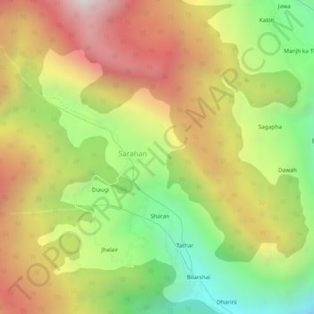
Name: Sarahan topographic map, elevation, terrain.

Location: Sarahan, Nermand, Kullu, Himachal Pradesh, India (31.52767 77.51566 31.56767 77.55566)

Average elevation: 2,581 m

Minimum elevation: 1,759 m

Maximum elevation: 3,469 m

Gear up for your next adventure:

🧥Softshell Hiking Jacket - The perfect balance of wind protection and breathability
🥾Hiking Leggings - Comfortable leggings for outdoor activities
Camping Tent - Weather-resistant tents suitable for 2 to 6 people
Family Camping Tent - Spacious tent suitable for family camping trips
🏃Hydration Running Vest - Carry water and maps close to your body for speed

As an Amazon Associate, this site earns from qualifying purchases at no extra cost to you.