Geolocate

Glenpool topographic map

Click on the map to display elevation.

About this map

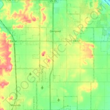
Name: Glenpool topographic map, elevation, terrain.

Location: Glenpool, Tulsa County, Oklahoma, 74033, United States (35.87125 -96.03339 35.98838 -95.95807)

Average elevation: 223 m

Minimum elevation: 179 m

Maximum elevation: 294 m

Other topographic maps

Click on a map to view its topography, its elevation and its terrain.

Turley

United States > Oklahoma > Tulsa County

Average elevation: 206 m

Southern Reserve

United States > Oklahoma > Tulsa County > Jenks

Average elevation: 197 m

Gear up for your next adventure:

🧴First Aid Kit - Essential first aid supplies for outdoor emergencies
🏕️Camping Hammock - Integrated protection for sleeping between trees
🧥Thermal Layer - Insulating layer for cold outdoor conditions
🥾Trekking Boots - Durable boots for long-distance trekking
🕯️Camping Lantern - Illuminates your entire campsite with high-efficiency LEDs

As an Amazon Associate, this site earns from qualifying purchases at no extra cost to you.