
Mundiyeruma topographic map
Click on the map to display elevation.
About this map
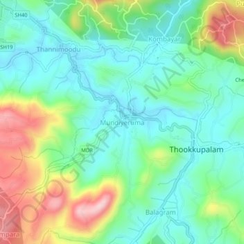
Name: Mundiyeruma topographic map, elevation, terrain.
Location: Mundiyeruma, Idukki, Kerala, 685552, India (9.79714 77.16127 9.83714 77.20127)
Average elevation: 908 m
Minimum elevation: 825 m
Maximum elevation: 1,092 m
Other topographic maps
Click on a map to view its topography, its elevation and its terrain.
Palakkad
Palakkad (Malayalam: [pɐːlɐkːɐːɖɨ̆] (listen)) is one of the 14 districts in the Indian state of Kerala. It was carved out from the southeastern region of the former Malabar District on 1 January 1957. It is located at the centre of Kerala. It is the largest district in the state since 2006. The city…
Average elevation: 306 m
Kannur
Kannur has an elevation of 1.02 metres or 3.3 feet along the coast of the Laccadive Sea, with a sandy coastal area. The city has an 8 kilometres (5.0 mi)-long seashore and a 3 kilometres (1.9 mi)-long beach at Payyambalam. Kannur is located north of Kozhikode, south of Kasargod and Mangalore, west of the…
Average elevation: 14 m