Geolocate

Meyrin topographic map

Click on the map to display elevation.

About this map

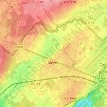
Name: Meyrin topographic map, elevation, terrain.

Location: Meyrin, Geneva, Switzerland (46.21717 6.04611 46.24715 6.11190)

Average elevation: 434 m

Minimum elevation: 366 m

Maximum elevation: 478 m

Gear up for your next adventure:

🥫Freeze-Dried Meals - Lightweight, high-calorie nutrition for multi-day treks
🩹Compact First Aid Kit - Pre-packed essentials for common trail injuries
🧭GPS Outdoor Watch - Smart watch for navigation and fitness tracking in nature
💧Filtered Water Bottle - Safe drinking water on the go
🥾Hiking Boots - Sturdy boots providing ankle support and traction on rugged trails

As an Amazon Associate, this site earns from qualifying purchases at no extra cost to you.