Geolocate

Vechoochira topographic map

Click on the map to display elevation.

About this map

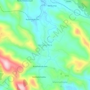
Name: Vechoochira topographic map, elevation, terrain.

Location: Vechoochira, Ranni, Pathanamthitta, Kerala, 686510, India (9.41511 76.83368 9.45511 76.87368)

Average elevation: 177 m

Minimum elevation: 78 m

Maximum elevation: 397 m

Other topographic maps

Click on a map to view its topography, its elevation and its terrain.

Ayiroor

India > Kerala > Ranni

Average elevation: 53 m

Perunthenaruvi Checkdam

India > Kerala > Ranni > Kurumbanmoozhy

Average elevation: 123 m

Keekozhoor

India > Kerala > Ranni > Peroorchal

Average elevation: 45 m

Perumthenaruvi

India > Kerala > Ranni > Mannadisala

Average elevation: 158 m

Perumthenaruvi

India > Kerala > Ranni > Mannadisala

Average elevation: 158 m

Edamuri

India > Kerala > Ranni > Chethackal

Average elevation: 123 m

Gear up for your next adventure:

🥾Light Trekking Boots - Supportive boots for multi-day treks
🧥Thermal Layer - Insulating layer for cold outdoor conditions
🕯️Camping Lantern - Illuminates your entire campsite with high-efficiency LEDs
🧥Packable Rain Jacket - Breathable waterproof layer for unpredictable weather
🧭Orienteering Kit - Tools for map reading and navigation in the wild

As an Amazon Associate, this site earns from qualifying purchases at no extra cost to you.