Geolocate

Maribo topographic map

Click on the map to display elevation.

About this map
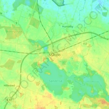
Name: Maribo topographic map, elevation, terrain.

Location: Maribo, Lolland Municipality, Region Zealand, 4930, Denmark (54.73580 11.46543 54.81580 11.54543)

Average elevation: 11 m

Minimum elevation: -2 m

Maximum elevation: 24 m

Other topographic maps

Click on a map to view its topography, its elevation and its terrain.

Lindholm

Denmark > Region Zealand

Average elevation: 0 m

Farø

Denmark > Region Zealand

Average elevation: 0 m

Møns Klint

Denmark > Region Zealand

Average elevation: 48 m

Lolland

Denmark > Region Zealand

Average elevation: 2 m

Falster

Denmark > Region Zealand

Average elevation: 3 m

Falster

Denmark > Region Zealand

Average elevation: 3 m

Vejrø

Denmark > Region Zealand

Average elevation: 0 m

Odsherred

Denmark > Region Zealand

Average elevation: 6 m

Falster

Denmark > Region Zealand

Average elevation: 3 m

Møn

Denmark > Region Zealand

Average elevation: 4 m

Nyord

Denmark > Region Zealand

Average elevation: 0 m

Great Belt

Denmark > Region Zealand

Average elevation: 8 m

Vejlø

Denmark > Region Zealand > Lindelse

Average elevation: 0 m

Lammefjorden

Denmark > Region Zealand > Gundestrup

The draining project began in 1873, but it took until 1943 before the lowest elevations were pumped dry. Large parts of the fjord were shallow enough to be dry early on. In 1899 the Odsherred Railway opened across the western end of the fjord. The town of Fårevejle Stationsby grew up where the railway…

Average elevation: 10 m
Femø

Denmark > Region Zealand > Nørreby

Average elevation: 2 m

Tissø

Denmark > Region Zealand > Sæby

Average elevation: 3 m

Gisseløre

Denmark > Region Zealand > Kalundborg

Average elevation: 3 m

Guldborg Sund

Denmark > Region Zealand

Average elevation: 6 m

Askø

Denmark > Region Zealand

Average elevation: 0 m

Gear up for your next adventure:

🧥Ultralight Puffy Jacket - Maximum warmth that packs down to the size of an orange
🎒Backpack Rain Cover - External shield to keep your entire pack dry
💡LED Headlamp - Hands-free illumination for night hiking and camping
🧥Softshell Jacket - Windproof and breathable jacket for hiking
🚲Handlebar Phone Mount - View topographic-map.com live while cycling

As an Amazon Associate, this site earns from qualifying purchases at no extra cost to you.