Geolocate

Day-as topographic map

Click on the map to display elevation.

About this map

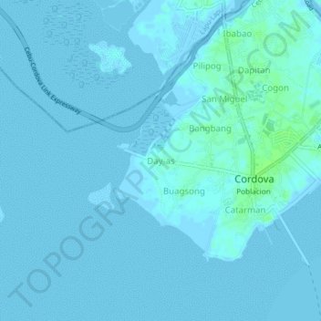
Name: Day-as topographic map, elevation, terrain.

Location: Day-as, Cordova, Cebu, Central Visayas, 6017, Philippines (10.23487 123.91775 10.27487 123.95775)

Average elevation: 1 m

Minimum elevation: -1 m

Maximum elevation: 9 m

Gear up for your next adventure:

🔦LED Flashlight - Powerful and long-lasting flashlight for camping and emergencies
Bushcraft Tarp - Versatile emergency shelter or gear protection
🔦LED Headlamp - Hands-free lighting for early morning starts or late finishes
🔦LED Headtorch - Bright and durable light for night activities
🪑Ultralight Camping Stool - Compact seating for rest stops during long hikes

As an Amazon Associate, this site earns from qualifying purchases at no extra cost to you.