Geolocate

Pampas topographic map

Click on the map to display elevation.

About this map

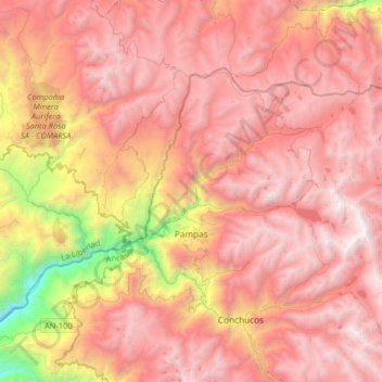
Name: Pampas topographic map, elevation, terrain.

Location: Pampas, Province of Pallasca, Ancash, Peru (-8.26917 -77.94263 -8.04971 -77.61875)

Average elevation: 3,730 m

Minimum elevation: 1,767 m

Maximum elevation: 4,867 m

Other topographic maps

Click on a map to view its topography, its elevation and its terrain.

Artesonraju

Peru > Ancash > Santa Cruz

Average elevation: 5,138 m

Huacapampa

Peru > Ancash > Huaraz

Average elevation: 3,215 m

Province of Bolognesi

Peru > Ancash

Average elevation: 3,102 m

Province of Yungay

Peru > Ancash

Average elevation: 2,668 m

Gear up for your next adventure:

🌬️Windproof Camp Stove - Efficient cooking even on exposed mountain peaks
Lightweight Camping Tent - Portable shelter optimized for Canadian backcountry camping
🥾Trekking Poles - Adjustable trekking poles to reduce knee stress and improve stability
🛏️Sleeping Bag - Warm and compact sleeping bags for outdoor camping
🎒Backpack Rain Cover - External shield to keep your entire pack dry

As an Amazon Associate, this site earns from qualifying purchases at no extra cost to you.