
Make a donation
Gear up for your next adventure:
As an Amazon Associate, this site earns from qualifying purchases at no extra cost to you.
Sainte-Paule topographic map
Click on the map to display elevation.
Make a donation
Gear up for your next adventure:
As an Amazon Associate, this site earns from qualifying purchases at no extra cost to you.
About this map
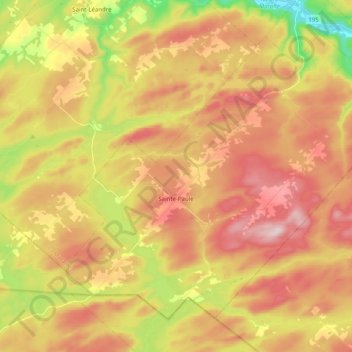
Name: Sainte-Paule topographic map, elevation, terrain.
Location: Sainte-Paule, La Matanie, Bas-Saint-Laurent, Quebec, Canada (48.61529 -67.62274 48.72279 -67.42277)
Average elevation: 235 m
Minimum elevation: 25 m
Maximum elevation: 407 m
La Matanie trails, hiking, mountain biking, running and outdoor activities
Make a donation
Gear up for your next adventure:
As an Amazon Associate, this site earns from qualifying purchases at no extra cost to you.
Other topographic maps
Click on a map to view its topography, its elevation and its terrain.
Make a donation
Gear up for your next adventure:
As an Amazon Associate, this site earns from qualifying purchases at no extra cost to you.