Geolocate

Melaque topographic map

Click on the map to display elevation.

About this map

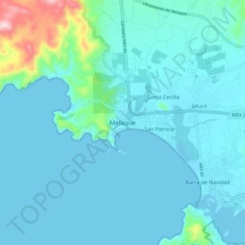
Name: Melaque topographic map, elevation, terrain.

Location: Melaque, Cihuatlán, Jalisco, 48985, Mexico (19.18510 -104.75154 19.26510 -104.67154)

Average elevation: 38 m

Minimum elevation: -2 m

Maximum elevation: 340 m

Gear up for your next adventure:

🏕️Camping Hammock - Integrated protection for sleeping between trees
🧢Outdoor Cap - Protective cap for sun and rain during hikes
Tent Footprint - Protect tent floor and increase durability
🧼Biodegradable Camp Soap - Environmentally friendly cleaning for gear and body
🥾Hiking Leggings - Comfortable leggings for outdoor activities

As an Amazon Associate, this site earns from qualifying purchases at no extra cost to you.