
Make a donation
Gear up for your next adventure:
As an Amazon Associate, this site earns from qualifying purchases at no extra cost to you.
Vordermurrhärle topographic map
Click on the map to display elevation.
Make a donation
Gear up for your next adventure:
As an Amazon Associate, this site earns from qualifying purchases at no extra cost to you.
About this map
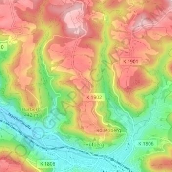
Name: Vordermurrhärle topographic map, elevation, terrain.
Average elevation: 396 m
Minimum elevation: 275 m
Maximum elevation: 517 m
Make a donation
Gear up for your next adventure:
As an Amazon Associate, this site earns from qualifying purchases at no extra cost to you.
Other topographic maps
Click on a map to view its topography, its elevation and its terrain.
Kirchenkirnberg
Deutschland > Baden-Württemberg > Rems-Murr-Kreis > Murrhardt
Das Dorf liegt auf etwa 460 m ü. NHN im Teilraum Kirnberger Wald des Naturraums Schwäbisch-Fränkische Waldberge, der eine erste Höhenstufe im Anstieg aus den Tälern von Fichtenberger Rot und Kocher zum höheren Welzheimer Wald bildet und vom Glattenzainbach nordöstlich zur Rot hin entwässert wird. Es…
Average elevation: 473 m