Geolocate

Clevedon topographic map

Click on the map to display elevation.

About this map

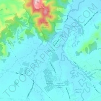
Name: Clevedon topographic map, elevation, terrain.

Location: Clevedon, Franklin, Auckland, New Zealand (-37.01100 175.01687 -36.97100 175.05687)

Average elevation: 37 m

Minimum elevation: 0 m

Maximum elevation: 241 m

Gear up for your next adventure:

🧥Softshell Jacket - Windproof and breathable jacket for hiking
🧦Outdoor Socks - Durable socks designed for hiking and outdoor sports
Camping Groundsheet - Protect your tent from moisture and dirt
🚲MTB Frame Bag - Carry tools and maps directly on your bicycle frame
🥽Outdoor Goggles - Protective eyewear for outdoor activities

As an Amazon Associate, this site earns from qualifying purchases at no extra cost to you.