
Thank you for supporting this site ❤️
Make a donation
Make a donation
Gear up for your next adventure:
As an Amazon Associate, this site earns from qualifying purchases at no extra cost to you.
Lagemichêne topographic map
Click on the map to display elevation.
Thank you for supporting this site ❤️
Make a donation
Make a donation
Gear up for your next adventure:
As an Amazon Associate, this site earns from qualifying purchases at no extra cost to you.
About this map
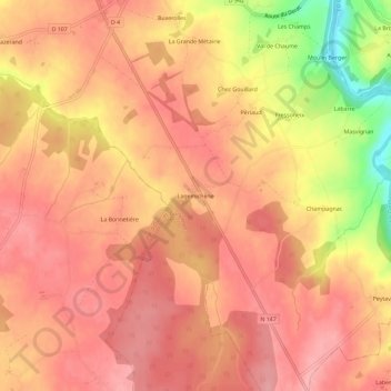
Name: Lagemichêne topographic map, elevation, terrain.
Average elevation: 213 m
Minimum elevation: 132 m
Maximum elevation: 243 m
Thank you for supporting this site ❤️
Make a donation
Make a donation
Gear up for your next adventure:
As an Amazon Associate, this site earns from qualifying purchases at no extra cost to you.
Other topographic maps
Click on a map to view its topography, its elevation and its terrain.
87320
France > Nouvelle-Aquitaine > Haute-Vienne > Val-d'Oire-et-Gartempe > Bussière-Poitevine > La Fétillière
Average elevation: 203 m