
Make a donation
Gear up for your next adventure:
As an Amazon Associate, this site earns from qualifying purchases at no extra cost to you.
Broechem topographic map
Click on the map to display elevation.
Make a donation
Gear up for your next adventure:
As an Amazon Associate, this site earns from qualifying purchases at no extra cost to you.
Broechem
Broechem ligt in de Kempen op een hoogte van 5-10 meter. In het noorden loopt het Albertkanaal met een spaarbekken en in het zuidoosten loopt het Netekanaal parallel aan de Kleine Nete.
Make a donation
Gear up for your next adventure:
As an Amazon Associate, this site earns from qualifying purchases at no extra cost to you.
About this map
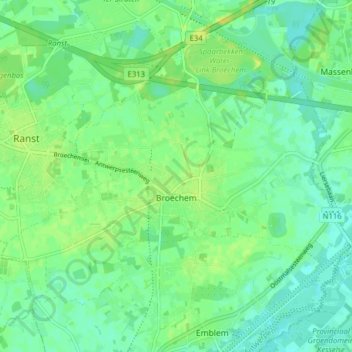
Name: Broechem topographic map, elevation, terrain.
Location: Broechem, Ranst, Antwerpen, Vlaanderen, 2520, België (51.16573 4.55775 51.20307 4.63611)
Average elevation: 9 m
Minimum elevation: 1 m
Maximum elevation: 18 m
Make a donation
Gear up for your next adventure:
As an Amazon Associate, this site earns from qualifying purchases at no extra cost to you.
Other topographic maps
Click on a map to view its topography, its elevation and its terrain.