Geolocate

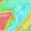
Oak Ridge topographic map

Click on the map to display elevation.

Oak Ridge

Green Pond Mountain, rising to over 1,260 feet (380 m) above sea level, forms the southern border of Oak Ridge and the border with Rockaway Township. Bowling Green Mountain, elevation 1,380 feet (420 m), borders the community to the southwest.

Wikipedia (CC-BY-SA 3.0)

About this map

Name: Oak Ridge topographic map, elevation, terrain.

Location: Oak Ridge, Jefferson Township, Morris County, New Jersey, 07438, United States (40.97982 -74.55564 41.07885 -74.44107)

Average elevation: 306 m

Minimum elevation: 225 m

Maximum elevation: 424 m

Other topographic maps

Click on a map to view its topography, its elevation and its terrain.
Gear up for your next adventure:

🛶Kayak Dry Bag - Waterproof storage for kayaking adventures
🥽Outdoor Goggles - Protective eyewear for outdoor activities
🔋Solar Power Bank - Keep your GPS and devices charged during long outdoor trips
🧤Thermal Hiking Gloves - Grip-enhanced gloves for cold-weather altitude trekking
Camping Essentials - All-in-one gear for a comfortable camping trip

As an Amazon Associate, this site earns from qualifying purchases at no extra cost to you.