Geolocate

Adwad topographic map

Click on the map to display elevation.

About this map

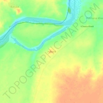
Name: Adwad topographic map, elevation, terrain.

Location: Adwad, Sheopur Tahsil, Sheopur, Madhya Pradesh, India (25.69803 76.49544 25.73803 76.53544)

Average elevation: 208 m

Minimum elevation: 185 m

Maximum elevation: 225 m

Other topographic maps

Click on a map to view its topography, its elevation and its terrain.

Karira

India > Madhya Pradesh > Sheopur Tahsil > Banwada

Average elevation: 217 m

Gear up for your next adventure:

🧢Sun Protection Cap - Breathable cap to protect from sun exposure
🧣Merino Neck Gaiter - Protects against wind, sun, and cold at high altitudes
🧦Thermal Socks - Warm socks for winter hiking or camping
🦟Insect Repellent - Keep mosquitoes and black flies away in wooded areas
🧊Portable Cooler - Keep food and drinks cold during outdoor adventures

As an Amazon Associate, this site earns from qualifying purchases at no extra cost to you.