Geolocate

Ghatsila topographic map

Click on the map to display elevation.

Ghatsila

Ghatshila is located at 22°36′N 86°29′E / 22.60°N 86.48°E / 22.60; 86.48. It has an average elevation of 103 m (338 ft).

Wikipedia (CC-BY-SA 3.0)

About this map

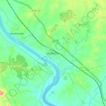
Name: Ghatsila topographic map, elevation, terrain.

Location: Ghatsila, Ghatshila, East Singhbhum, Jharkhand, 832303, India (22.54531 86.43682 22.62531 86.51682)

Average elevation: 107 m

Minimum elevation: 71 m

Maximum elevation: 205 m

Gear up for your next adventure:

🛁Quick-Dry Microfiber Towel - Space-saving towel that dries rapidly on the move
🧭GPS Outdoor Watch - Smart watch for navigation and fitness tracking in nature
💧Hydration Bladder - Hands-free hydration solution for long treks
🥾All-Terrain Hiking Boots - Versatile boots for varied hiking conditions
🧦Hiking Liner Socks - Thin base layer to prevent friction and blisters

As an Amazon Associate, this site earns from qualifying purchases at no extra cost to you.