
Bad Salzungen topographic map
Interactive map
Click on the map to display elevation.
About this map
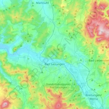
Name: Bad Salzungen topographic map, elevation, terrain.
Location: Bad Salzungen, Wartburgkreis, Thüringen, Duitsland (50.74188 10.05870 50.91356 10.34263)
Average elevation: 347 m
Minimum elevation: 228 m
Maximum elevation: 718 m
Other topographic maps
Click on a map to view its topography, its elevation and its terrain.
In den Görlitz Lieden
Duitsland > Thüringen > Wartburgkreis > Vacha > Martinroda
In den Görlitz Lieden, Martinroda, Vacha, Wartburgkreis, Thüringen, 36404, Duitsland
Average elevation: 387 m